Publisher:
Bonnie King
CONTACT:
Newsroom@Salem-news.com
Advertising:
Adsales@Salem-news.com

~Truth~
~Justice~
~Peace~
TJP
Mar-24-2011 17:05

 TweetFollow @OregonNews
Storms Bearing Down on California, West Coast
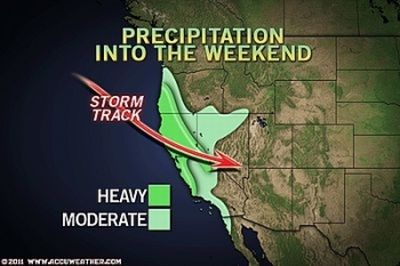
Salem-News.comRainfall totals in the Southland will be around 0.50 of an inch. While this will be significantly lighter than in the north, it could still be enough to cause mudslides and minor flooding problems.
 Courtesy: AccuWeather.com |
(LOS ANGELES) - With more rain on the way, California residents are preparing for dangerous flooding and mudslides, while mountain resorts are looking at record snowfall.
Rain will fall in buckets across northern and central California today, while AccuWeather.com meteorologists are watching two other systems on the horizon.
This first storm will threaten to drop over an inch of rain across much of northern California, while the end result of the three storms could total upwards of 3 inches or more in some locations.
Even more devastating could be the close proximity of the storms, with very little drying time between them. As the first system exits on Friday, the second will arrive Friday night. Meanwhile, the third will follow on its heels.
The saturated ground could give way to devastating consequences.
Expert Meteorologist Alex Sosnowski first warned about the threat of flash and urban flooding, debris flows and mudslides on Wednesday.
Farther south, Los Angeles and San Diego will be spared the worst of the storm.

Rainfall totals in the Southland will be around 0.50 of an inch. While this will be significantly lighter than in the north, it could still be enough to cause mudslides and minor flooding problems.
Elsewhere across the region, lighter showers are expected across the Northwest today, while heavier moisture could develop this weekend.
Along with the bouts of heavy rain, some storms could contain heavy, gusty thunderstorms with hail.
Snow Piling Up in the Sierra
Resorts across the Sierra Nevada are continuing to build on an impressive snow season where some areas have had over 600 inches of snowfall.
To put that in perspective, the snowiest winter on record at Donner Summit was in 1937-1938, where 819 inches (over 68 feet), fell. The snowiest April recorded at Donner Summit was in 1880, when 298 inches (nearly 25 feet) of snow fell.
That total would place Donner Summit well within reach of setting a new seasonal snowfall record.
As for today, another 12-18 inches of snow could fall across the mountains, while 2-4 feet could accumulate by Friday morning. The highest peaks could see amounts near 5 feet. Meanwhile snow levels will range between 2,000 and 4,000 feet.
Farther south, snow levels the San Gabriel Mountains and other ranges in the Southland will range from 4,000 to 5,000 feet.
Motorists should expect delays and road closures and have tire chains ready.
Damaging Winds
Winds across the interior of northern California will become strong once again. Sustained winds will be 20 to 40 mph, while some gusts could reach 70 mph.
The worst of the wind will occur early in the day, then decrease into the afternoon. Damage is possible to trees and power lines, while gusts will make driving difficult and dangerous.
In the Sierra Nevada, wind gusts to 60 mph will create blowing and drifting and lead to dangerous white-out conditions.
By Eric Reese, Meteorologist
Source: AccuWeather.com.
Articles for March 23, 2011 | Articles for March 24, 2011 | Articles for March 25, 2011


Quick Links
DINING
Willamette UniversityGoudy Commons Cafe
Dine on the Queen
Willamette Queen Sternwheeler
MUST SEE SALEM
Oregon Capitol ToursCapitol History Gateway
Willamette River Ride
Willamette Queen Sternwheeler
Historic Home Tours:
Deepwood Museum
The Bush House
Gaiety Hollow Garden
AUCTIONS - APPRAISALS
Auction Masters & AppraisalsCONSTRUCTION SERVICES
Roofing and ContractingSheridan, Ore.
ONLINE SHOPPING
Special Occasion DressesAdvertise with Salem-News
Contact:AdSales@Salem-News.com

Terms of Service | Privacy Policy
All comments and messages are approved by people and self promotional links or unacceptable comments are denied.
gp March 24, 2011 5:43 pm (Pacific time)
Drenching rains hit Gayle, Sweden just when the radioactive cloud passed over contaminating this town over a thousand miles from Chernobyl. This brought the radioactive Iodine, Cesium and Strontium to ground and the population had an excessive illness rate thereafter. There was a very preventable rash of thyroid cancer. I hope the public health officials will tell people to stay indoors and take iodine. Of course there is not much to be done about the other radioactive particles except try to enhance your immune system.
gp March 24, 2011 5:42 pm (Pacific time)
Drenching rains hit Gayle, Sweden just when the radioactive cloud passed over contaminating this town over a thousand miles from Chernobyl. This brought the radioactive Iodine, Cesium and Strontium to ground and the population had an excessive illness rate thereafter. There was a very preventable rash of thyroid cancer. I hope the public health officials will tell people to stay indoors and take iodine. Of course there is not much to be done about the other radioactive particles except try to enhance your immune system.
[Return to Top]©2026 Salem-News.com. All opinions expressed in this article are those of the author and do not necessarily reflect those of Salem-News.com.