Publisher:
Bonnie King
CONTACT:
Newsroom@Salem-news.com
Advertising:
Adsales@Salem-news.com

~Truth~
~Justice~
~Peace~
TJP
Aug-04-2021 15:19

 TweetFollow @OregonNews
Middle Fork Complex Update and Evacuations
Salem-News.comLEVEL 3 (GO NOW) EVACUATION NOTICE: All homes, campgrounds and dispersed recreation along Forest Service Road 18 (Big Fall Creek Road) east of the intersection with Forest Service Road 1821, including Puma Campground and Bedrock Campground.
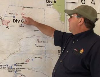
 Middle Fork Complex Daily Update with NW9 Deputy Incident Commander Steve Hawkins. |
(LANE COUNTY, Ore.) - Twelve individual fires make up the Middle Fork Complex, with seven fires at 100% containment. The most active fire in the complex is the Gales Creek Fire at 1,822-acres with 0% containment located south of the Forest Road 18 near the 1835 road.
Indirect suppression efforts will continue with heavy equipment building contingency lines to the west and south on the 1824 road. Crews will re-open containment lines from previous fires and install hose lays to keep fire away from private land and structures to the northwest.
The 333-acre Kwis Fire is the second largest fire in the complex and is 25% contained. The Kwis Fire is the closest fire to Oakridge, located south of Forest Road 24 near Salmon Creek.
Yesterday, the west flank of Kwis fire was tied into Salmon Creek. The focus today will be along the eastern flank.
On the 184-acre Ninemile Fire, engines and crews will continue to build containment lines and prep for indirect containment line on the 1832 Road. Crews will continue mop up and patrol at the five-acre Packard fire, securing the fire edge.
The following fires are 90-100% contained beginning from north to south:
- Symbol Rock
- Journey
- Devils Canyon
- Warble
- Larison Cove
- Way
- Windfall
Crews will continue to monitor, patrol and secure line as needed. Hose lays along containment lines will be installed.
Aviation: Air assets provide support to ground resources with water drops to limit the spread of the fire and to help establish and hold containment lines. Air support today includes two Type 1 heavy Blackhawk helicopters, one medium Type 2 helicopter and two light Type 3 helicopters.
Weather and Air Quality: Warmer today with 90 degree temperatures and winds from the WNW 6-8 m.p.h., gusting to 17 m.p.h. Air quality Advisory in affect this afternoon for Oakridge, Oregon area today. Air quality index shows unhealthy for sensitive groups.
Children, older adults and people with lung disease should avoid outdoor exertion. More information can be found at oakridgeair.org.
Closures: There are updated closure orders for the Salmon Creek area on the Willamette National Forest as of August 4, 2021. Go to the Forest webpage at www.fs.usda.gov/willamette or follow on Facebook.
Evacuations: Effective July 30, 2021, the following are evacuation levels issued through Lane County.
- Level 3 (GO NOW) Evacuation Notice: All homes, campgrounds and dispersed recreation along Forest Service Road 18 (Big Fall Creek Road) east of the intersection with Forest Service Road 1821, including Puma Campground and Bedrock Campground, are at a Level 3.
Source: firenet.gov
Articles for August 3, 2021 | Articles for August 4, 2021 | Articles for August 5, 2021


googlec507860f6901db00.html
Quick Links
DINING
Willamette UniversityGoudy Commons Cafe
Dine on the Queen
Willamette Queen Sternwheeler
MUST SEE SALEM
Oregon Capitol ToursCapitol History Gateway
Willamette River Ride
Willamette Queen Sternwheeler
Historic Home Tours:
Deepwood Museum
The Bush House
Gaiety Hollow Garden
AUCTIONS - APPRAISALS
Auction Masters & AppraisalsCONSTRUCTION SERVICES
Roofing and ContractingSheridan, Ore.
ONLINE SHOPPING
Special Occasion DressesAdvertise with Salem-News
Contact:AdSales@Salem-News.com


Terms of Service | Privacy Policy
All comments and messages are approved by people and self promotional links or unacceptable comments are denied.
[Return to Top]
©2026 Salem-News.com. All opinions expressed in this article are those of the author and do not necessarily reflect those of Salem-News.com.