Publisher:
Bonnie King
CONTACT:
Newsroom@Salem-news.com
Advertising:
Adsales@Salem-news.com

~Truth~
~Justice~
~Peace~
TJP
Jun-30-2008 20:58


 TweetFollow @OregonNews
Plains States Will See Returning Storms (VIDEO)
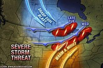
Salem-News.comStorms moving into the northern Plains late Tuesday will reach the flood-weary Midwest by Wednesday.
 Images and video: Accuweather.com |
(OMAHA, Neb.) - Forecasters at Accuweather.com, say high pressure building in the Midwest region out of the West Tuesday, will bring a blast of heat to the northern Plains. They predict temperatures through Tuesday to be in the 90s across the Intermountain West and the northern Plains.
 As that heat gives way late Tuesday to a cold front droping out of Canada's Prairie Provinces, a quick-hitting, dynamic storm system will follow the front onto the northern Plains. By Wednesday, storms will move into the upper Mississippi Valley, Accuweather experts say.
The clash of cooler air with the heat pushing out of the south and west will spark a new round of severe storms producing heavy rain, hail, damaging winds and potential for tornadoes.
On Tuesday, storms will drop out of the northern Rockies onto the northern Plains. By early Wednesday, the system will reach the Upper Midwest before spreading into the lower Great Lakes late in the day.
The storms will not be welcome in Omaha, Neb., where many residents could be without power for most of the week. A powerful storm ripped through the city on Friday.
Wind gusts of 110 to 115 mph were recorded as the storm bore down on Omaha Despite slowing, 70- to 90-mph gusts slammed the city, knocking down trees and power lines and leaving more than 30,000 customers without power.
According to Severe Weather Expert Henry Margusity, "It does appear that parts of the soggy Mississippi Valley will have more heavy rain with the storms Wednesday into Thursday."
Any heavy downpours from the storm could have an impact on the flooding in the Mississippi River. Associated Press reports that the river level at St. Louis today is leveling off at just under 9 feet above flood stage and is expected to stay there through Tuesday.
Some businesses, including a casino, a couple of riverboat excursions and a bike rental business near the Gateway Arch, remain closed due to the high water. City officials say the annual Independence Day festival will be moved away from the grounds of the Gateway Arch to the downtown area, which sits well above the river.
The river downstream at Cape Girardeau, Mo., is expected to crest on Wednesday at 42.5 feet, 12.5 feet above flood stage.
Thousands of acres of farmland are flooded, but the city of Cape Girardeau is being protected by a floodwall. Local officials expect few homes will be affected by flooding.
The situation upriver in hard-hit Lincoln County, Mo., is slowly improving. The water that flooded hundreds of homes in Foley and Winfield is slowly starting to recede. However, it will be weeks before a full assessment of the damage is complete.
Source: Accuweather.com
Articles for June 29, 2008 | Articles for June 30, 2008 | Articles for July 1, 2008
Quick Links
DINING
Willamette UniversityGoudy Commons Cafe
Dine on the Queen
Willamette Queen Sternwheeler
MUST SEE SALEM
Oregon Capitol ToursCapitol History Gateway
Willamette River Ride
Willamette Queen Sternwheeler
Historic Home Tours:
Deepwood Museum
The Bush House
Gaiety Hollow Garden
AUCTIONS - APPRAISALS
Auction Masters & AppraisalsCONSTRUCTION SERVICES
Roofing and ContractingSheridan, Ore.
ONLINE SHOPPING
Special Occasion DressesAdvertise with Salem-News
Contact:AdSales@Salem-News.com


Salem-News.com:

Terms of Service | Privacy Policy
All comments and messages are approved by people and self promotional links or unacceptable comments are denied.
[Return to Top]
©2026 Salem-News.com. All opinions expressed in this article are those of the author and do not necessarily reflect those of Salem-News.com.