Publisher:
Bonnie King
CONTACT:
Newsroom@Salem-news.com
Advertising:
Adsales@Salem-news.com

~Truth~
~Justice~
~Peace~
TJP
Dec-04-2009 13:19

 TweetFollow @OregonNews
Two Storms to Descend on California
Salem-News.comLandslides and mudflow could be disastrous in burn areas.
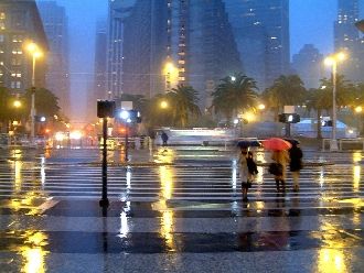
 Courtesy: thomashawk.com |
(LOS ANGELES) - AccuWeather.com Senior Meteorologist Ken Clark reported in his blog that a stormy pattern is descending on California, bringing two storms, one of Sunday through Monday, the other on Wednesday and Thursday.
The lead storm
Rain and snow will break out in northern California Sunday night and spread rapidly south late Sunday night and Monday. Snow levels are likely to be only 1,000 feet in the north, about 1,500 to 2,000 feet around the Bay Area to the Central Coastal Mountains, and down to 3,500 to 4,500 feet from the Los Angeles County Mountains to San Diego.
Total liquid precipitation is likely to range from a 0.25 to 0.50 of an inch in northern California to 0.50 to 1.00 inch in central and Southern California, with locally higher amounts in upslope areas.
Wednesday and Thursday storm
This will be a warmer storm with the strong potential for a pineapple connection.
Heavy precipitation would fall over all of central and Southern California, with widespread 1.50- to 4.00-inch rain amounts. However, with a projected strong low-level south and southwest jet modeled, this could lead to some places, especially on west- and south-facing slopes of the mountains from the central coastal south to Southern California, receiving three to four times that much precipitation.
If these model projections are even close to being right, we are staring straight in the face of widespread flooding problems. Even worse, around recent burn areas, and especially the huge Station Fire burn area, mudslides and debris flows could be disastrous
================================================
Special thanks to Justin Roberti and AccuWeather.com
Articles for December 3, 2009 | Articles for December 4, 2009 | Articles for December 5, 2009


Quick Links
DINING
Willamette UniversityGoudy Commons Cafe
Dine on the Queen
Willamette Queen Sternwheeler
MUST SEE SALEM
Oregon Capitol ToursCapitol History Gateway
Willamette River Ride
Willamette Queen Sternwheeler
Historic Home Tours:
Deepwood Museum
The Bush House
Gaiety Hollow Garden
AUCTIONS - APPRAISALS
Auction Masters & AppraisalsCONSTRUCTION SERVICES
Roofing and ContractingSheridan, Ore.
ONLINE SHOPPING
Special Occasion DressesAdvertise with Salem-News
Contact:AdSales@Salem-News.com

Terms of Service | Privacy Policy
All comments and messages are approved by people and self promotional links or unacceptable comments are denied.
[Return to Top]
©2026 Salem-News.com. All opinions expressed in this article are those of the author and do not necessarily reflect those of Salem-News.com.