Publisher:
Bonnie King
CONTACT:
Newsroom@Salem-news.com
Advertising:
Adsales@Salem-news.com

~Truth~
~Justice~
~Peace~
TJP
Nov-11-2014 22:01

 TweetFollow @OregonNews
Wintry Mix to Slick Washington, Oregon Late Week
AccuWeather Special to Salem-News.comPortland and Salem lie in the "cold zone" and will have to prepare for treacherous travel to unfold and possible power outages.
 Image courtesy: AccuWeather |
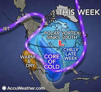
(SALEM, Ore.) - The blast of arctic air spreading across the nation will set the stage for a winter storm to threaten the Northwest later this week.
Frigid air will not only spend this week pouring across the eastern two-thirds of the nation, but will also continue to spill into the Northwest.
As the cold air expands southwestward, gusty winds will create even lower temperatures through Wednesday.
As the cold air squeezes through the Columbia Gorge, winds will pick up speed in a fashion similar to what happens between buildings in a city. Gusts of 40 to 60 mph can occur near the western mouth of the gorge into Wednesday.
The strongest winds will whip Troutdale, Oregon, with gusts of 50 mph expected in Portland.
Such winds could cause tree damage and power outages. Dangerous cross-winds will threaten high-profile vehicles, including those traveling Interstate-84 as it snakes along the Columbia River and the portion of I-5 in the Portland, Oregon, area.
As the winds die down later Wednesday, attention will then turn toward a new Pacific storm due to arrive late in the week.
While the storm will be far from the strongest to slam the region, the presence of the cold air will set the stage for snow and ice to fall outside of the mountains and create travel hazards.
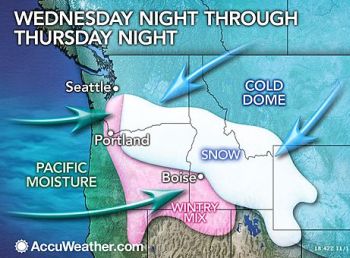
Current indications point toward an icy mix developing along the I-5 corridor in northern Oregon and southern Washington Wednesday night through Thursday morning.

Portland and Salem, Oregon, lie in this zone and will have to prepare for treacherous travel to unfold and possible power outages.
Farther to the north, snowflakes may make an appearance just to the south of Seattle Thursday morning. A northward shift to the storm, however, could spread the wintry mix threat to Seattle.
A band of accumulating snow is also set to create slippery roads across eastern Oregon and southern Idaho Wednesday night through Friday. This includes The Dalles, Bend and Pendleton, Oregon, and Boise, Idaho. A few inches could fall in this swath.
Exactly how much snow falls in this area and over southeastern Washington will depend on how far north the storm tracks and how much warm air sweeps in above the ground.
Residents of the Northwest should continue to check back with AccuWeather.com as more precise details on this impending winter storm unfold.
Drier weather will return next weekend as the storm heads eastward to cross the remainder of the country. Through Monday of the following week, the storm may lay a swath of snow from the central Plains to the Northeast.
RELATED: Northwest Regional Radar AccuWeather.com Winter Weather Center Forecast Temperature Maps
Source: AccuWeather.com (First published: http://www.accuweather.com/en/weather-news/cold-portland-seattle-ice/37104325)
 |
Articles for November 10, 2014 | Articles for November 11, 2014 |

Salem-News.com:

Quick Links
DINING
Willamette UniversityGoudy Commons Cafe
Dine on the Queen
Willamette Queen Sternwheeler
MUST SEE SALEM
Oregon Capitol ToursCapitol History Gateway
Willamette River Ride
Willamette Queen Sternwheeler
Historic Home Tours:
Deepwood Museum
The Bush House
Gaiety Hollow Garden
AUCTIONS - APPRAISALS
Auction Masters & AppraisalsCONSTRUCTION SERVICES
Roofing and ContractingSheridan, Ore.
ONLINE SHOPPING
Special Occasion DressesAdvertise with Salem-News
Contact:AdSales@Salem-News.com


Terms of Service | Privacy Policy
All comments and messages are approved by people and self promotional links or unacceptable comments are denied.
[Return to Top]
©2026 Salem-News.com. All opinions expressed in this article are those of the author and do not necessarily reflect those of Salem-News.com.