Publisher:
Bonnie King
CONTACT:
Newsroom@Salem-news.com
Advertising:
Adsales@Salem-news.com

~Truth~
~Justice~
~Peace~
TJP
Aug-27-2006 13:15

 TweetFollow @OregonNews
Civil Air Patrol Nearing End of Seismic Survey
Salem-News.comCivil Air Patrol wings from several state are participating.
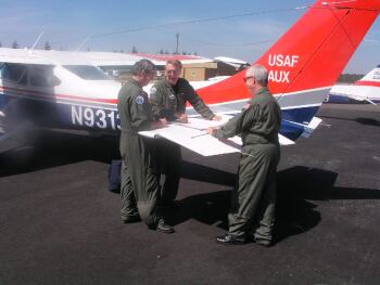
 CAP aerial photographer Lt. Nick Ham goes over mission flight with CAP Pilot Capt. Dennis Wyza and CAP Observer John Barringer. CAP crew, all of the CAP Salem Unit, utilized new Satellite Digital Imaging System for aerial photography in support of USGS Survery. Photo: Oregon Civil Air Patrol |
(SALEM) - The Oregon Wing of the Civil Air Patrol, along with other CAP Wings, is nearing completion of it's participation in an extensive six state seismic survey mission in cooperation with the United States Geological Survey and the and the California Office of Emergency Services Clearinghouse that is being conducted from August 16th through August 31st.
The CAP in Oregon was operating out of Willamette Aviation at the Aurora State Airport as well as bases in Medford, and Eugene. Other CAP wings (states) participating in the exercise were California, Alaska, Hawaii, and Nevada with Oregon covering targets in Washington as well.
The seismic survey event, comprising simulated volcanic as well as earthquake activity, involved numerous aircraft and corresponding air crews, ground support personnel and communications specialists and is part of a national program to better understand and respond to local seismic danger spots and practice emergency response to a major seismic event in the Pacific Northwest.
The exercise involved a series of geological targets that were prepared for use in the reconnaissance missions during the overall exercise based on actual historical events and research by Geologists at USGS in Menlo Park, CA to identify some earthquake/volcano related "targets" in HI, AK, WA, OR, CA and NV said CAP spokesman, Lt.Col. Thomas Traver, public affairs officer for the Oregon Wing of the CAP.
 |
"This exercise will be used not only to gather information for the USGS, but will also serve to train new and existing air crews and ground personnel in disaster response and to effectively utilize new technology in disaster triage, rescue and recovery operations" said Traver
"The photos taken will be actually used by the USGS research team to further their understanding and knowlege of local geology as it pertains to potential future seismic events." he added.
"The U.S. Geological Survey (USGS) has responsibilites to the Nation in many critical areas involving the earth sciences and natural hazards. In the present context, the issues are national hazard reduction programs for earthquakes, volcanoes, and tsunami.
These goals can best be achieved if optimum use is made of available resources; this is especially critical in times of diminished circumstances" explained Dr. John Tinsley of the USGS.
In the present example, the USGS is cooperating with the Civil Air Patrol (CAP) and the California Office of Emergency Services Clearinghouse to explore ways in which mutual aid and cooperation can speed the evaluation of earthquake effects on society.
If the CAP personnel can be of rapid and effective assistance in documenting earthquake surface ruptures, ground failures owing to liquefaction and landsliding, or effects of erupting volcanoes on lifelines and other infrastructure, then the USGS will become much more efficient in discharging the Survey's mission responsibilities following any natural disaster." he said. Oregon CAP Seismic Survey
Rich Davies of the California office of Emergency Serivces Clearing house remarked "I want to emphasize that we believe that the CAP is a great resource and needs to be utilized more for things like this. They can provide VERY cost effective and quick reaction imagery collection after a major natural disaster."
"The quality of the images obtained has been exemplary and the desireability of forging lasting partnerships among the USGS, the CAP, and California Office of Emergency Services has been demonstrated at least to the satisfaction of this participant.

Doubtless other states will be watching and learning, and the expectation is that national emergency response planning will evolve towards ever greater capability in the near future." said Dr. Tinsley.
According to the USGS, more than half of the world's active volcanoes above sea level encircle the Pacific Ocean to form the circum-Pacific "Ring of Fire."
There are more than 500 active volcanoes (those that have erupted at least once within recorded history) in the world -- 50 of which are in the United States (Hawaii, Alaska, Washington, Oregon, and California) -- although many more may be hidden under the seas.
If high enough in magnitude, earthquakes will cause Tsunamis. Between June 30th and July 11th, 2006, there were sixteen earthquakes on the western coastline of Alaska between 4.4 and 5.9 magnitude, none of which was strong enough to create a tsunami. As of May 30, 2006 there were 29 Tsunami ReadyTM sites in 7 states, with 4 on the west coast of Alaska, Washington, Oregon, and California.
For more information on Oregon CAP please go to www.orwg.cap.gov or our national web site please go to www.cap.gov.
Preparation for disastrous earthquakes created by high intensity seismic activity can be found at www.ready.gov; www.fema.gov or from the www.geophys.washington.edu/recenteqs.
For more information on the Pacific Rim and "Ring of Fire" www.vulcan.wr.usgs.gov
For information on seismic activity in relation to the Pacific Ocean and Pacific Rim States: www.legislative.noaa.gov/Testimony/johnson012605.pdf
Articles for August 26, 2006 | Articles for August 27, 2006 | Articles for August 28, 2006


Quick Links
DINING
Willamette UniversityGoudy Commons Cafe
Dine on the Queen
Willamette Queen Sternwheeler
MUST SEE SALEM
Oregon Capitol ToursCapitol History Gateway
Willamette River Ride
Willamette Queen Sternwheeler
Historic Home Tours:
Deepwood Museum
The Bush House
Gaiety Hollow Garden
AUCTIONS - APPRAISALS
Auction Masters & AppraisalsCONSTRUCTION SERVICES
Roofing and ContractingSheridan, Ore.
ONLINE SHOPPING
Special Occasion DressesAdvertise with Salem-News
Contact:AdSales@Salem-News.com
Salem-News.com:
Terms of Service | Privacy Policy
All comments and messages are approved by people and self promotional links or unacceptable comments are denied.
[Return to Top]
©2026 Salem-News.com. All opinions expressed in this article are those of the author and do not necessarily reflect those of Salem-News.com.