Publisher:
Bonnie King
CONTACT:
Newsroom@Salem-news.com
Advertising:
Adsales@Salem-news.com

~Truth~
~Justice~
~Peace~
TJP
Jan-27-2008 15:57


 TweetFollow @OregonNews
Heavy Snow Warning Issued for Willamette Valley (VIDEO)
Tim King Salem-News.comWeather experts say that during these conditions, you should only drive if it is absolutely necessary and also remember to bring a flashlight, food, water and even extra dry clothes and a blanket for maximum preparation.
 Images and video courtesy: Accuweather.com |
(SALEM, Ore.) - A Heavy Snow Warning has been issued for the Willamette Valley of Oregon. Snow began falling in downtown Salem a little after 3:00 PM. The National Weather Service heavy snow warning will remain in effect until 4:00 PM Monday. Portland and several other Oregon cities and regions are also impacted.
Today's rain and snow is expected to increase tonight and Monday. Today the snow level is close to 500 feet and it is expected to reach the valley floor tonight and Monday.
Spotters reported 7 inches of snow near Lebanon at 800 feet and 2 inches were reported in Eugene. This means that snow amounts of 2 to 3 inches are possible today with 3 to 8 inches above 500 feet.
 Weather experts say you should only drive if it is absolutely necessary and also remember to bring a flashlight, food, water and even extra dry clothes and a blanket for maximum preparation.
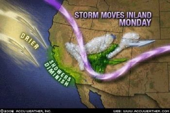
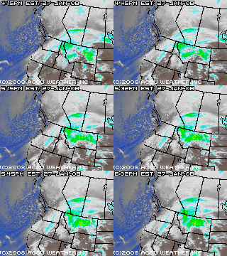
Accuweather.com reports that a powerful storm system will continue to affect much of the West coast into Monday as it moves inland, bringing rain and snow to much of the region. California will continue to see heavy rain, thunderstorms and mountain snow. The whole storm will push inland Monday, bringing heavy mountain snow to the Rockies and Intermountain West and a few showers to the Southwest.
 Salem Snow Sunday, Photo: Crystal Young |
The flooding rainfall will combine with the threats we have seen from the fires this summer and autumn to bring mudslides across Southern California. Already this week, mudslides have been reported, and we expect to see more of these with the heavy rainfall moving through the area. According to Ken Clark's Blog, some of the southern-facing mountains may get upwards of 4 to 8 inches of rain from this storm, with another 2-4 feet of snow in mountains over 7,000 feet by the time the storm winds down.
As the storm presses into the Intermountain West through Monday, colder air will follow. The Sierra-Nevada, Cascades and Rockies will receive a walloping. The Sierra will receive the brunt of the snow with 1 to 2 feet extremely likely. Combined with high winds, blizzard conditions will be in store for this region. At the same time, areas of southern California that have been pounded by rain will see the rain diminish to a few showers.
Meanwhile, a cold storm will affect the Northwest with snow making it to the Northwest coast Sunday night. It will even be cold enough for snow in Seattle where 1-3 inches may accumulate through Monday.
Source: Accuweather.com and the National Weather Service.
Articles for January 26, 2008 | Articles for January 27, 2008 |


googlec507860f6901db00.html


Terms of Service | Privacy Policy
All comments and messages are approved by people and self promotional links or unacceptable comments are denied.
[Return to Top]
©2026 Salem-News.com. All opinions expressed in this article are those of the author and do not necessarily reflect those of Salem-News.com.